Who Drew Africa’s Borders? A Map of Colonial Africa vs. Africa Today
We should establish a couple of things about precolonial Africa before diving deeper into this post. First is that back in the old days, nation-states weren’t ubiquitous in the Motherland, as they are today. There were a handful of larger political entities though, especially, it would appear, in the north.
But that was not the general modus operandi. The Motherland was rather ruled by virtually-innumerable smaller kingdoms and tribes.

A political mapping of African in 1880, prior to the official age of European colonialism
Also, it wasn’t until the European Age of Expansion that the entirety of Africa was mapped. So Africans themselves did not know how big the continent was, if you will. If certain kingdoms did and were seafarers like Europeans, it’s safe to presume that they would have expanded their territories.
THE SCRAMBLE FOR AFRICA
It was European colonial powers who collectively proceeded to dominate the Africa. They were competitors but at the same time understood the value of teaming up to partition the vast, resource-rich continent. Co-exploiting peacefully was preferable to conflict. So with Belgium’s King Leopold II leading the charge, the colonials saw fit to legally establish agreed-upon African territories.

A depiction of the Berlin Conference (Germany) in 1884. Notice how there aren’t any Africans present.
That took place during the Berlin Conference of the mid-1880s. By that point, the colonizers had already been taking advantage of Africa for years, with no end in sight. So to reiterate, they found it most expedient to officially divvy the land amongst themselves. Not a single African leader attended the conference. That shows how confident colonial Europe was in its wherewithal to spread and maintain control in the Motherland.
THE COLONIAL AFRICAN MAP
The map that resulted from the Berlin Conference influenced the borders present-day African countries and in some instances defined them. But it wasn’t a map of states, rather of colonial territories. In other words, it outlined the boundaries of the lands under control of respective European colonizers. France and Great Britain got bigger share, followed by the likes of Belgium, Germany, Portugal and, to a noticeably-lesser extent, Spain.

The colonial map of Africa
If you compare the European colonial mapping of Africa to the map of the Motherland we use today, you will notice that quite a few current countries did have their boundaries defined by the Berlin Conference. These include the likes of Ghana, Nigeria, the Democratic Republic of Congo, West Sudan, Namibia, Mozambique, Somalia and a few more. But again, the goal of the Europeans was not to establish independent states. Those boundaries demarcated colonial areas of administration, not being meant to promote autonomous nationhood.
For instance, up until it achieved independence from the British in 1957, Ghana was known as the Gold Coast. And that was due to Great Britain’s extraction on gold from that particular colony. The General Act of Berlin, which sprang from the conference, was a European legal document that was subsequently enforced upon the weaker Africans.
DIFFERENCES BETWEEN COLONIAL VS. PRESENT-DAY MAP OF AFRICA
So if you were to look at the European colonial map, you’ll notice that most of northwestern was considered, in the eyes of prevailing international law, a territory of France, as opposed to independent nation-states. Nowadays, the countries that former area comprises include Algeria, Mali, etc.
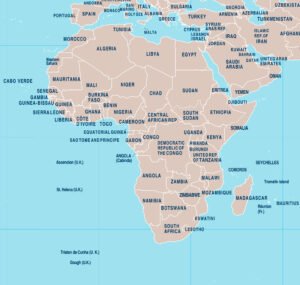
A map of Africa from 2019
A large British territory in the mid-south eventually became Zimbabwe, Zambia, Botswana and (most of) South Africa. An even larger holding by Great Britain in the northeast consisted of present-day Egypt, Sudan, Uganda, etc. In these cases, it was usually the colonizers themselves eventually who broke the territories down into smaller units, many of which still stand today.
So not all of the initial boundaries defined by the Europeans remained intact, and there were other factors that changed them. For instance, Italy and Great Britain once shared what has since become Libya. A single German colonial holding on the Atlantic coast now makes up Cameroon, as well as parts of Nigeria, Chad, the Central African Republic, Gabon and the Republic of Congo. There has also been civil wars and domestic disputes that have influenced the borders of countries.
CONCLUSION
The colonial map of Africa, as developed by European powers circa the late-19th century, shares many similarities to the map of Africa we use today. It was during that era that the boundaries of many African countries were designated.
The biggest difference is that the largest colonial holdings have since been broken down into smaller nations. That’s what you’ll likely notice most when comparing the two maps. European countries administered much larger sections of the Motherland than individual African nations hold sway over today.